Capture of Fort Eben-Emael

The fortifications at Eben-Emael were key to the Belgian delaying operations in front of the Dyle-Breda Line. The German plan to send its Sixth Army around Liège required that the river crossings west of Maastricht be captured intact. The bridges across the Albert Canal at Kanne, Vroenhoven, and Veldwezelt were under the fortress’s guns, and they had to be neutralized for any invasion in this sector to succeed.

Built in 1935, Eben-Emael was thought to be the strongest fort in the world. Its armaments included two 120-mm guns and sixteen 75-mm guns – all of them in armored turrets or casemates. To the northeast, the canal cut’s steep sides rose 40 meters above the canal waters and formed an ideal glacis for protection from attack across the canal. In other directions, antitank trenches, barbed wire, and bunkers provided protection. Machine guns swept the approaches. Defensive positions were linked by tunnels that also linked the underground barracks, storerooms, and hospital. Ventilation was provided through filters which offered protection from poison gas. Twelve hundred men commanded by Major Jean Jottrand were assigned to the fort, although many were billeted in the neighboring villages and hence not permanently within its perimeter.

40 Capture of Fort Eben-Emael
10 May 1940
Region: Wallonia
Country: Belgium

A French Battlefields “Virtual Battlefield Tour” as described in Fields of War: Fifty Key Battlefields in France and Belgium.

Summary: In the predawn darkness of 10 May, eleven gliders left airfields around Cologne. Their departure was timed for arrival at the fort at 05:30, H-hour for the invasions of Belgium, Holland, and Luxembourg. Towed behind fifty-two Junkers JU 87 transport aircraft, the gliders climbed to an altitude of 2,100 meters before being released 20 km from the Belgium frontier. Two of the attack gliders became lost during the flight, including that of the assault commander, Oberleutnant Witzig.

Major Jottrand had alerted his troops at approximately 03:00, when he received reports of German troop movements toward the border. The confusion caused by the silent approach of the gliders and small arms fire from the direction of the canal bridges, however, had prevented the fortress from firing. Antiaircraft gunners hesitated to fire against aircraft that they could not definitely identify as hostile.

View Capture of Fort d’Eben-Emael – A Virtual Battlefield Tour by French Battlefields (www.frenchbattlefields.com) in a larger map

Continue reading

Siege of Liege

The German Schlieffen Plan required the defeat of the French army before Germany turned eastward to face the larger, but slowly mobilizing Russian forces.  The German plan considered the Ardennes region as too rugged and without a road network sufficient to support the large military movements required to face the French Army. Thus, the thirty-four divisions of the German First, Second, and Third Armies were to be funneled around Liège through the 16 km gap between the Netherlands and the Ardennes. Not wanting to pull The Netherlands into the conflict, the plan carefully remained south of the Dutch territory of Maastricht. Belgian resistance was expected to be little more than symbolic.

13 Siege of Liege
5 to 16 August 1914
Region: Wallonia
Country: Belgium

A French Battlefields “Virtual Battlefield Tour” [This battlefield is not included in Fields of War.]

Summary: The German Army of the Meuse, commanded by General Otto von Emmich crossed the border on 4 August with six brigades of infantry and three cavalry divisions (II Calvary Corps under Generalleutnant Georg von der Marwitz). His orders were to capture the bridges over the Meuse River at Liège for use by larger following forces. The opening engagement of the First World War was on.

On 4 August, Fort Barchon was the first fortification attacked, but Infantry Regiment 53 was driven back with heavy losses. On 5 August, the 2nd and 4th Cavalry Divisions forded the Meuse to the north at Lixhe. Belgian troops were quick to destroy the bridges above and below the city and German efforts to construct temporary crossings came under fire from the fortifications.

View Siege of Liege – A Virtual Battlefield Tour by French Battlefields (www.frenchbattlefields.com) in a larger map

Continue reading

Farmer’s Museum

The fields and forests northwest of Verdun, bordered by the Meuse River on the east and the Forêt d’Argonne on the west, were the scene of the most intense fighting experienced by American forces during the First World War. The engagement raged from 26 September to 11 November 1918 and, because of the geography, became known as the Meuse-Argonne Offensive. The combined French / American offensive was successful and contributed to the Germans seeking the Armistice which ended the war on 11 November.

Fighting northward through Varennes-en-Argonne, the Americans confronted a series of strong German defensive lines, or Stellung, given the names Hagen, Giselher, Kriemhilde, and Freya after characters in Wagnerian operas. The third of these was the most extensive and presented attackers with an almost continuous 10-mile belt of machine-gun positions and barbed wire. The terrain provided numerous opportunities for mutually supporting cross- and enfilade-fire and it exposed attackers to shelling from artillery hidden in the forests.

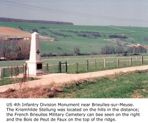
It was mid-spring 2005 and I had been in the area for several days reviewing the sites relating to the battle. On one particular afternoon, I drove the roadways near Brieulles-sur-Meuse to view the Kriemhilde Stellung terrain. Beside the road was a stone monument to the US 4th ‘Ivy’ Infantry Division, which had suffered 7,412 casualties in the brutal local fighting. I wanted a photograph and, contrary to my normal policy of finding a safe, public area to park, I instead turned onto muddy, farm track. After all, it was a quiet afternoon and nobody was about.

Struggling to get a perspective of the monument with the forests and hills of the stellung in the background, I climbed up a 7 foot verge and walked 300 feet or so along it. No sooner had I positioned myself, than I heard the rumble of heavy farm machinery. I knew immediately that it had to be coming down the farm track now blocked by my parked rental car. I hastened along the top of the verge and slipped down the steep incline in time to meet the tractor that had stopped just inches away from the car’s front bumper. I prepared myself for a tongue-lashing in French, or worse. The tractor’s driver stepped out of the cab and climbed down – presenting me with what I thought must be the largest farmer in northern France. Continue reading